
I didn’t care if Jeremy Nobis could ski the Great Wall in one turn. Hell, I could ski the Wall if I had helicopters and a safety crew. I did care, though, if the Wall stopped our trip. I’d never get over flying home without finishing the Tordrillo Traverse.
Distracted from my thoughts, I watched Dylan punch knee-deep into avalanche debris above the bergschrund. Sunshine warmed the slope. Another hour and avalanches would start, but by then we’d have crossed the pass and be descending the shady Great Wall. Dylan stopped thirty feet below the pass, sensing a cornice, and arched out left, fighting thigh deep slop.
Crossing the pass and descending the Wall would ensure success. A year earlier, when Andrew and I first tried to ski the full length of the Tordrillo Mountains—a western extension of the Alaska Range—the 2,000-vertical foot, 14-mile long Great Wall stopped us. We had camped for four days below the Wall and watched seracs and avalanches rip the passable routes until our food bags emptied and we called Paul Roderick to fly us out. Now, a year later, Andrew and I watched as Dylan peered down the Great Wall from a rock outcrop. He didn’t say anything, but dumped his pack and looked around.
We’d either descend the Wall or fail again.

The Tordrillo Mountains above Anchorage. The highest summit on the left in this photo is Mount Spurr. Our route started at Chakachamna Lake, which is just left of Spurr and finished off left of the photo.
Tordrillo Traverse round two began in spring 2008 with more artillery. Dylan Taylor signed on, an IFMGA guide and friend of many trips, including a 22-day trip across the Neacola Mountains in Alaska.
In Anchorage, we finished loading our 60-liter packs just as a low settled over Kodiak Island and hammered the Tordrillos with southerly storms. Biding time, I continued life at home with Cathy, while Dylan and Andrew made the typical climber-bachelor rounds of Kaladi Coffee, the Bear Tooth Grill, and the Great Alaska Base Camp.
“I’m reaching the tipping point between resting and eating and getting fat and weak,” Andrew said after seven days of fermenting in Anchorage. During brief spurts of planning, we’d lay out the USGS maps and scrutinized photos in Tordrillo: Pioneer Climbs and Flights in the Tordrillo Mountains. When the wind shifted to the north, we raced to Doug Brewer’s hangar in Kenai. In three separate flights, he crammed us into his Piper Super Cub with our 65-pound packs, flew across Cook Inlet and crawled out below Mount Spurr—the southern end of the Tordrillo Mountains loomed above. In twelve days we hoped to emerge on the Skwentna River at the far north end of the range.

Doug Brewer starting his Super Cub the old fashioned way in Nikiski.
In 2004 Dylan skied off Spurr’s dormant summit with three unruly Alaskans and two dogs. Now, Andrew and I followed him as we started up 9,000-feet of volcano trudge.
“When was the last time you skied, Wex?” I asked Andrew.
“Three days ago when we tested our new gear,” Andrew said.
“Before that?”
“At least four months. It’s cool. I’ll lead the overhanging limestone pitches,” Andrew said, referring to his winter hiatus in Thailand.

Dylan skinning toward the summit of Mount Spurr. Neacola Mountains beyond.
We camped between Crater Peak and Mount Spurr feeling strong and psyched in the cold, clear weather. In the morning, we sidled around to the 10,000-foot Spurr Plateau, dumped our packs, and followed Dylan among crevasses and seracs to the rim of a deep, smoldering crater and the 11,070-foot summit.
“I remember this being a rounded summit,” Dylan said. “Chris Bremer’s dog fell 40 feet into the only crevasse we saw. We yelled ‘sit!’ into the crack until I rescued him.” We looked north toward the other three Tordrillos high points we aimed to tag. “I know. This is the new crater from the 2006 eruption.” Dylan said.

Joe, Andrew and Dylan on the summit of Mount Spurr above the 2006 crater.
That night we packed into our Hilleberg tent on the Spurr Plateau and passed around the maps. Tomorrow was the first big unknown—a 4,000-foot icefall into the Capps Glacier. Our only information was a blurry photo in the Tordrillo book showing a jumbled mass of seracs sliced by a steep cleaver.

Andrew likes how the stench in his boots is progressing.
In cold, high elevation sun, we toured from Spurr’s steaming cone into the maw of the Capps icefall. For 2,000 vertical feet, we bombed through deep powder, skimming over sunken crevasse bridges. Far below, the icefall rolled over and vanished from sight. The location and powder would make Teton Gravity Research cry with envy, but this was reality. No film crew, no helicopters, no local guides. Just three friends lugging heavy packs, knowingly dropping into a labyrinth of deep, icy cracks.
“It feel like my pants are down and my hands are cuffed to my ankles,” Andrew yelled from a teetering serac with black chasms on three sides. “This won’t go. Toss me a rope and let’s skin out of here.” We climbed from the cu-de-sac, keeping the rope bowstringed to minimize a crevasse fall. We tried another corridor, and another, until our options reduced to crossing the steep cleaver splitting the icefall. From the flanks of the cleaver, we looked up at a forty-degree slope rising above an open bergschrund. Any avalanche would mean death in nature’s worst terrain trap. The cleaver option required trucker stability. I expected Andrew to take the lead. He always led in committing terrain. Instead, he was quiet, oddly interested in the snowpack. We stomped on test slopes and banged on stability columns for two hours, but found no weak layers.
“I’ll do it,” Dylan said, and he plowed a single arching track above the bergschrund to the cleaver’s crest. While following Dylan’s trail I wondered why Andrew hadn’t volunteered. I recalled that the Canadian Rockies endured a grueling avalanche season last winter. Just before leaving to climb in Patagonia, Andrew’s partner, Ben Firth, barely survived an avalanche and would never climb again.
From the crest of the cleaver we saw a route through the crevasses beyond. First we had to get down there—an even steeper slope dropped to another hungry bergschrund. Again Andrew hesitated. I sidestepped down the 45-degree crest and built a ski anchor. On belay, Dylan made leaping turns through a river of sloughing snow that poured into the bergschrund. After 100 feet, Dylan unclipped and picked down the face and jumped the bergschrund to the glacier below. Soon we roared between crevasses to the valley floor and stripped to let our bodies steam like fumaroles in the low-elevation sun.

Andrew stripping in the low elevation heat after descending the 4,000-foot southeast cirque icefall of the Capps Glacier from the Spurr Plateau. Our route descended lookers left of the spur, then crossed over the spur and finished the lookers right icefall.
“I was at my friend Susanna’s house when they called about Ben’s accident,” Andrew said. “A month later Susanna was killed in an avalanche.” I looked at Andrew and understood. I still didn’t trust snow, thirteen years after watching my climbing partner get avalanched to his death in New Zealand.
We toured the remainder of the day down the Capps Glacier and camped on a broad pass above the Triumvirate Glacier. Orange granite towers split by pinner couloirs encircled the icefield. Chugach Powder Guides, a Girdwood-based heli-ski operation, rules this region. In 2006 they opened the Tordrillo Mountain Lodge and began heli-dropping world-class athletes onto the apex of these runs. Soon the Tordrillos entered pop ski culture through Warren Miller and Teton Gravity Research.
From our couloir-lined low camp we moved to 7,000 feet on the Triumvirate Glacier. The next day, we skied 20 miles and 8,000 vertical feet to the summits of Torbert and Talachulitna, located at opposite ends of the Torbert Plateau. With three summits down, one to go, the crux— the Great Wall—still lay ahead.

Dylan leaving our packs behind as we head to the summit of Torbert.

Dylan skiing at 10,000 feet on Torbert. Revelation Mountains beyond.
On day six, we slept until the morning sun warmed the Solio, charged the I pod, and brought 2pac to life. We skied north and rested below a short, steep pass. On the other side lay the Great Wall. Our tactic, revised after the harsh lesson in 2007, was to attack the Wall from the top, assessing the starting zone stability rather than guessing from below.
We boot-packed to the corniced pass and looked down the shortest section of the Great Wall. The 1,500-foot face of snow-covered ice dropped at 40 to 45 degrees—one turn for Jeremy Nobis, the no-turn, all-mountain revolutionary, maybe 20 for us if we didn’t have 50-pound packs or a gaping bergschrund waiting at the bottom.

Joe belaying Andrew down from the top of the Great Wall. We found the 45-degree face had 12 inches of powder over ice and an open bergshrund below. With light packs this would have been a great ski. We used a 100-foot rope and three 18-foot cordelletes tied together to give us 145-feet.
“That’s a piece of real estate,” Andrew said.
For two hours we discussed options, tossed rocks, and cut cornices, eventually settling on a snowy spur leading down the face. I linked three cordelettes onto the 100-foot rope to create a 150-foot rope. Using a buried ski, I belayed Andrew as he kicked steps down the snow-covered ice to the end of the rope and placed a two-screw anchor. He unclipped and I belayed Dylan down. From below, Dylan belayed me as I downclimbed, unprotected and keenly aware that I’d fall 300 feet before the rope would catch me. We continued this way for four pitches until we all hung from a final ice anchor. We clipped into our skis and side-slipped to the bergschrund and launched the gapping black crack. Yelling like drunken frat boys, we made GS turns to the glacial flats.
The icefall and Great Wall behind us, we slept late and lazily skied from Gerdine’s 11,125-foot summit. For thousands of feet we skied tight powder corridors and jumped crevasses down the Trimble Glacier until gravity stopped working. Sitting on our packs, we drank protein shakes with our shirts off as the evening sun colored the snow orange.

Andrew skiing into the 3,000-foot Trimble Glacier icefall from near the summit of Mount Gerdine. Martin Peak in the near distance, central Alaska Range in far distance.
“I’d say we did the trip,” Andrew said. “Let’s call Roderick for a pickup. We’ll be partying at the Fairview tonight.” His voice was dreamy and persuasive, fraught with images of young women pressed around him at his favorite Talkeetna establishment. Two years earlier, on our traverse of the Neacola Mountains, I’d convinced Dylan and Andrew to bushwack for days to reach Little Lake Clark, a landmark perhaps a bit beyond the true southern boundary of the Neacola Mountains, but what I saw as the real end point of that trip. Now, Andrew was leery of my idea to end our trip at the Skwentna River at the northern tip of the Tordrillos.
“What about the full-length traverse?” I said to Andrew.
“We did the Tordrillo summit traverse,” Andrew said. “That’s the trip.”
“I’m going to the Skwentna River. Here’s the phone if you want to call Roderick,” I said and tossed him the sat phone.
“I’d like to go to the Skwentna,” Dylan said, quietly swinging the vote in my favor.
“What’s it like getting down to the Skwentna?” Andrew said.
“A mile of bushwhacking at the most,” I said.
“You sure?” Andrew said.
“You want to see the map?” I said.
“I believe you. Just don’t say the word ‘bushwhack’. Or ‘bear.’ I don’t like bears.”

Traversing the Hayes Glacier.
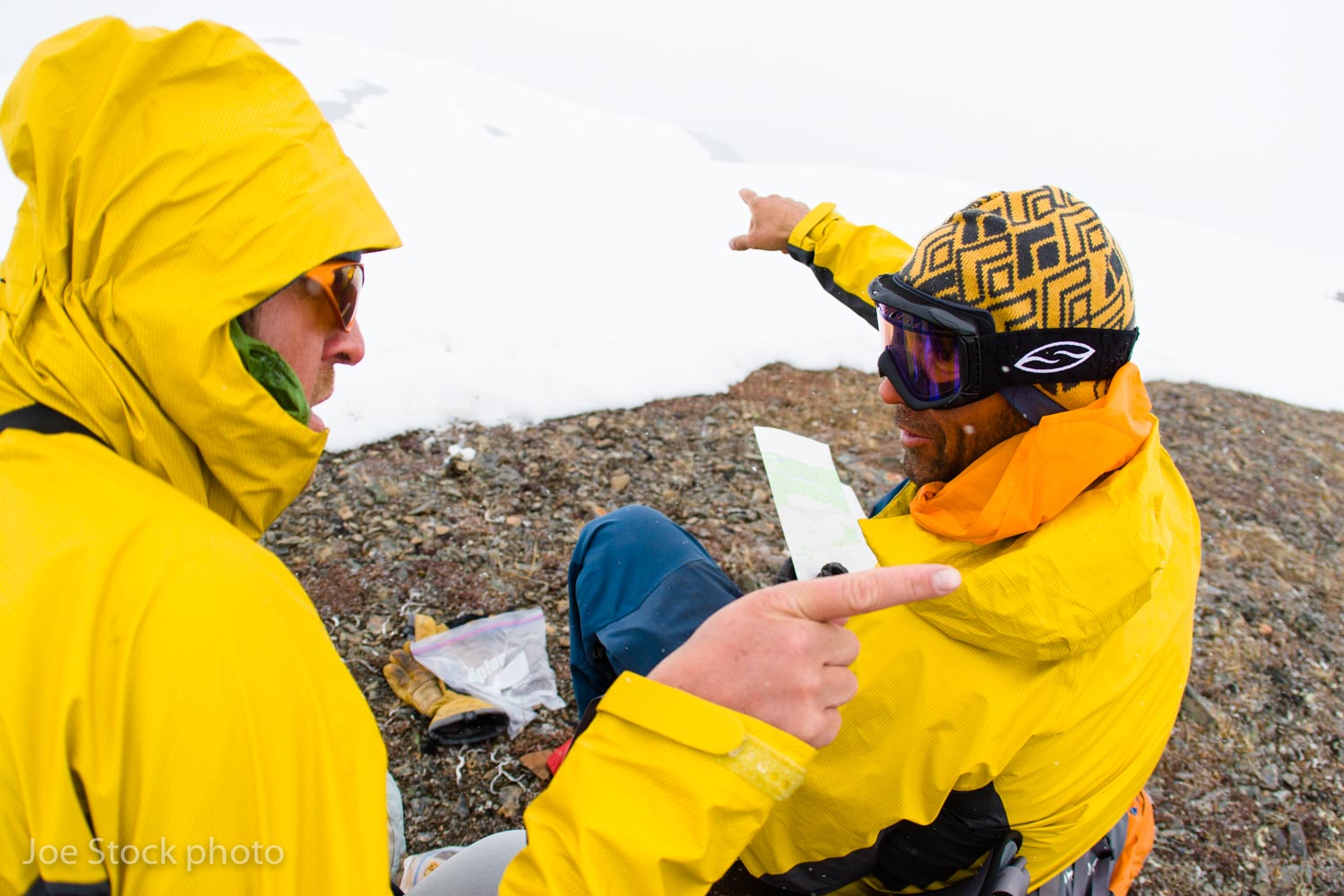
A typical in-the-fog route finding discussion above the Skwentna River.
Fighting mounting exhaustion, we skied through fog and wind for two days over steep passes and down small pocket glaciers to the northern boundary of the Tordrillos. Nine days after leaving Kenai, we ripped down an avalanche-debris-choked chasm into a grove of mammoth cottonwoods lining the Skwentna River floodplain. Despite the May heat, two feet of snow still covered the gravel bars.
An eerie loneliness hung in the valley, like a painting of a trapper’s cabin in old Alaska on the wall of a cheap hotel. Across the river channel, the Iditarod trail wound through spruce trees toward Rainy Pass, just as it had for a hundred years. With our food bags empty, I felt the panic of isolation and imagined thrashing for days on an empty stomach to reach the highway.
I gathered myself and dug out the phone. Forty-eight hours later, Spernak Airways dropped us at Merrill Field in Anchorage and we clomped down the sidewalk to my house.

Dylan and my favorite part of every trip. Andrew doesn't partake.

Back in Merrill Field with our mail plane. We hired a taxi to drive us the half mile to my house.

Joe on the summit of Mount Gerdine, the second highest Tordrillo summit at 11,258 feet in April 2007.